Tectonic collision course
View Sequence overviewStudents will:
- identify the cause of earthquakes as tectonic plate movement.
- identify evidence that supports the movement of tectonic plates.
- examine the development of the theory of plate tectonics.
- understand that the Earth consists of different layers.
- explain how new evidence or different perspectives can lead to changes in scientific knowledge.
Students will represent their understanding as they:
- compare geological evidence and biological evidence of tectonic plate movement.
- develop a timeline of the development of scientific theories.
- describe how new evidence can lead to changes in science knowledge.
In this lesson, assessment is formative.
Feedback might focus on students’ ability to:
- describe how tectonic plates have moved over time.
- identify evidence that supports the movement of tectonic plates.
- identify the different layers of the Earth.
- explain how new evidence or different perspectives can lead to changes in scientific knowledge.
Potential summative assessment
Students working at standard should:
- examine the evidence that led to the acceptance of the theory of plate tectonics over the idea of continental drift.
- develop investigable questions to explore scientific models, such as: How do the shapes of the continents support the theory of plate tectonics?
Whole class
Tectonic collision course Resource PowerPoint
Each student
Individual student notebook
Gondwana fossil Resource sheet or Gondwana geoscience Resource sheet
Cracking the code of moving plates Resource sheet printed on A3 paper
Scissors
Lesson
The Inquire phase allows students to cycle progressively and with increasing complexity through the key science ideas related to the core concepts. Each Inquire cycle is divided into three teaching and learning routines that allow students to systematically build their knowledge and skills in science and incorporate this into their current understanding of the world.
When designing a teaching sequence, it is important to consider the knowledge and skills that students will need in the final Act phase. Consider what the students already know and identify the steps that need to be taken to reach the level required. How could you facilitate students’ understanding at each step? What investigations could be designed to build the skills at each step?
Read more about using the LIA FrameworkRe-orient
Pose the question: Did we have an earthquake in Australia yesterday?
Discuss the likelihood of earthquakes in Australia.
If required, refer to the Geoscience Australia earthquake monitoring website and select Recent Earthquakes > 30 days.
The Inquire phase allows students to cycle progressively and with increasing complexity through the key science ideas related to the core concepts. Each Inquire cycle is divided into three teaching and learning routines that allow students to systematically build their knowledge and skills in science and incorporate this into their current understanding of the world.
When designing a teaching sequence, it is important to consider the knowledge and skills that students will need in the final Act phase. Consider what the students already know and identify the steps that need to be taken to reach the level required. How could you facilitate students’ understanding at each step? What investigations could be designed to build the skills at each step?
Read more about using the LIA FrameworkIdentifying and constructing questions is the creative driver of the inquiry process. It allows students to explore what they know and how they know it. During the Inquire phase of the LIA Framework, the Question routine allows for past activities to be reviewed and to set the scene for the investigation that students will undertake. The use of effective questioning techniques can influence students’ view and interpretation of upcoming content, open them to exploration and link to their current interests and science capital.
When designing a teaching sequence, it is important to spend some time considering the mindset of students at the start of each Inquire phase. What do you want students to be thinking about, what do they already know and what is the best way for them to approach the task? What might tap into their curiosity?
Read more about using the LIA FrameworkThe Earth moves
Pose the question: How far/much does the Earth move during an earthquake?
Discuss how it can be hard to tell exactly how far the Earth moves during a single earthquake. Most scientists study earth movements over a much long time period.
(Slide 12) Pose the question: How do scientists study how the Earth moves over time?
How to recognise and address alternative conceptions
When teaching about tectonic plates, consider where common alternative conceptions or misconceptions might appear.

When planning for a lesson, consider where common alternative conceptions or misconceptions might appear. Build in questions or activities that help bring these ideas to the surface, rather than waiting for them to appear on their own.
Give students plenty of chances to talk in pairs or small groups. While they’re discussing, move around the room and listen in—this is often the best way to observe misunderstandings.
When you do notice a misconception, take time to explore it with the class. Encourage students to explain their thinking and help each other work out why an idea might not be quite right. An example of this is included in the potential discussion prompts where students are encouraged to think about the solid mantle layer that can still flow like tar. These questions could be followed up with practical activities or additional Inquire phase lessons so students can see for themselves how their understanding has changed.
Most importantly, create a positive classroom culture where it’s okay to get things wrong. Let students know that mistakes are part of learning and use misconceptions as helpful stepping stones towards deeper understanding.
| Alternative conception | Accepted conception |
| The mantle layer is liquid rock. | The mantle is a solid but ductile flowing layer of rock. |
| The tectonic plates move by convection. | While convection is a factor, there are other forces such as slab pull that also apply. |
| Subduction is always one plate moving underneath another. | While denser rock will subduct (i.e. oceanic or oldest coldest crust), when two plates are similar densities they may form mountains. |
| Earthquakes are measured on the Richter scale. | ‘Moment magnitude’ scale is used today and is based on the physical properties of the fault. This includes the rigidity of the rock, the distance the rock slipped and the area of the fault zone. Use the term Magnitude. |
| The biggest magnitude is M10. | There is no limit, but a M10 is unlikely as it would require a fault line completely around the Earth. |
| There are no volcanoes in Australia. | There are currently dormant and extinct volcanoes in Australia. |
The Inquire phase allows students to cycle progressively and with increasing complexity through the key science ideas related to the core concepts. Each Inquire cycle is divided into three teaching and learning routines that allow students to systematically build their knowledge and skills in science and incorporate this into their current understanding of the world.
When designing a teaching sequence, it is important to consider the knowledge and skills that students will need in the final Act phase. Consider what the students already know and identify the steps that need to be taken to reach the level required. How could you facilitate students’ understanding at each step? What investigations could be designed to build the skills at each step?
Read more about using the LIA FrameworkThe Investigate routine provides students with an opportunity to explore the key ideas of science, to plan and conduct an investigation, and to gather and record data. The investigations are designed to systematically develop content knowledge and skills through increasingly complex processes of structured inquiry, guided inquiry and open inquiry approaches. Students are encouraged to process data to identify trends and patterns and link them to the real-world context of the teaching sequence.
When designing a teaching sequence, consider the diagnostic assessment (Launch phase) that identified the alternative conceptions that students held. Are there activities that challenge these ideas and provide openings for discussion? What content knowledge and skills do students need to be able to complete the final (Act phase) task? How could you systematically build these through the investigation routines? Are there opportunities to build students’ understanding and skills in the science inquiry processes through the successive investigations?
Read more about using the LIA FrameworkGondwana
(Slide 13) Divide the students into teams of biologists and geologists and provide each student with either the Gondwana fossil Resource sheet or the Gondwana geoscience Resource sheet. Encourage each student to cut out the different continents and fit them together so that the common elements match across the different continents.
Allow students time to rearrange their puzzles so that the continents are joined.
Gondwana puzzle pieces
Several major geological structures provide strong evidence that the southern continents were once joined together as Gondwana.
Several major geological structures provide strong evidence that the southern continents were once joined together as Gondwana. One of the most noticeable pieces of evidence is the way continental margins fit together. The coastlines of South America, Africa, Antarctica, India, and Australia align closely, like pieces of a puzzle, suggesting they were once connected before drifting apart.
Continuous mountain belts also support this connection. Mountain ranges and rock formations of the same age and composition are found on continents that are now widely separated. When the continents are reconstructed into Gondwana, these geological structures line up, indicating they formed as part of the same mountain-building events.
Glacial deposits provide further evidence. Late Paleozoic glacial sediments and striations (scratch marks left by moving ice) are distributed across the southern continents. When these landmasses are placed back together, the glacial patterns align around a central ice sheet, showing they were once part of a single, colder southern landmass.
Matching rock sequences and mineral deposits across these continents also indicate a shared geological history. Identical sedimentary layers suggest they were formed in the same environments before the continents separated. In addition, the distribution of identical fossils across these regions supports the idea of a united landmass, as many of these organisms could not have crossed large oceans. Together, these geological structures provide clear and interconnected evidence for the existence of Gondwana.
The geological evidence puzzle has drawings of four organisms that represent the different time periods during the formation of Gondwana.
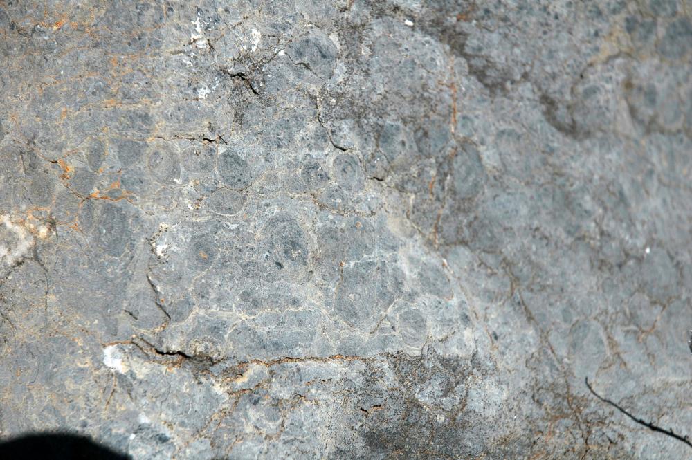
Both Charnia and Funisia lived during the Ediacaran Period (635–541 million years ago) before the Cambrian explosion. Preserved fossils of these organisms have been found in South Australia, which was part of Gondwana at the time.
Trilobites are found in Cambrian rock layers across Australia including Kangaroo Island and central Northern Territory.
Anomalocaris, a large Cambrian predator, is known from Australian fossil sites such as the Emu Bay Shale on Kangaroo Island in South Australia.
Useful resources
600 Million Years: Victoria Evolves. (n.d.). Museums Victoria. https://museumsvictoria.com.au/melbournemuseum/resources/600-million-years/
Meet the who’s who of the Ediacara world. (2023). Good Living. https://www.environment.sa.gov.au/goodliving/posts/2023/05/nilpena-ediacara-park-fossils
Several major geological structures provide strong evidence that the southern continents were once joined together as Gondwana. One of the most noticeable pieces of evidence is the way continental margins fit together. The coastlines of South America, Africa, Antarctica, India, and Australia align closely, like pieces of a puzzle, suggesting they were once connected before drifting apart.
Continuous mountain belts also support this connection. Mountain ranges and rock formations of the same age and composition are found on continents that are now widely separated. When the continents are reconstructed into Gondwana, these geological structures line up, indicating they formed as part of the same mountain-building events.
Glacial deposits provide further evidence. Late Paleozoic glacial sediments and striations (scratch marks left by moving ice) are distributed across the southern continents. When these landmasses are placed back together, the glacial patterns align around a central ice sheet, showing they were once part of a single, colder southern landmass.
Matching rock sequences and mineral deposits across these continents also indicate a shared geological history. Identical sedimentary layers suggest they were formed in the same environments before the continents separated. In addition, the distribution of identical fossils across these regions supports the idea of a united landmass, as many of these organisms could not have crossed large oceans. Together, these geological structures provide clear and interconnected evidence for the existence of Gondwana.
The geological evidence puzzle has drawings of four organisms that represent the different time periods during the formation of Gondwana.
Both Charnia and Funisia lived during the Ediacaran Period (635–541 million years ago) before the Cambrian explosion. Preserved fossils of these organisms have been found in South Australia, which was part of Gondwana at the time.
Trilobites are found in Cambrian rock layers across Australia including Kangaroo Island and central Northern Territory.
Anomalocaris, a large Cambrian predator, is known from Australian fossil sites such as the Emu Bay Shale on Kangaroo Island in South Australia.
Useful resources
600 Million Years: Victoria Evolves. (n.d.). Museums Victoria. https://museumsvictoria.com.au/melbournemuseum/resources/600-million-years/
Meet the who’s who of the Ediacara world. (2023). Good Living. https://www.environment.sa.gov.au/goodliving/posts/2023/05/nilpena-ediacara-park-fossils
The supercontinents
There were two stages of Gondwana formation during Earth’s geological history.
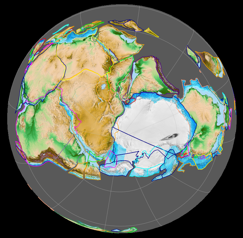
There were two stages of Gondwana formation during Earth’s geological history. Initially, Gondwana formed 800-650 Ma, before combining with Laurasia (containing what would become North America, Europe and Asia – excluding India) during the Triassic period 250-50 Ma. It brought together nearly all of Earth’s landmasses into a single connected continent, surrounded by a global ocean called Panthalassa. Evidence for Pangaea includes the jigsaw-like fit of continents, matching rock layers and mountain belts across oceans, and identical fossils found on now-separated continents.
During the Jurassic period (180 Ma), Pangaea began to break apart due to plate tectonic processes driven by heat and convection in the mantle. As the lithosphere stretched and thinned, rifting occurred, leading to the formation of new ocean basins. This breakup did not happen all at once but in stages over tens of millions of years.
Africa and South America separated as the Atlantic Ocean opened. India broke away and moved rapidly north, eventually colliding with Asia and forming the Himalayas. Australia moved northward after separating from Antarctica, influencing its changing climate and biodiversity.
Laurasia also broke apart, with North America separating from Europe as the North Atlantic opened. Eurasia continued to evolve through collisions with smaller plates and continental blocks.
The movements of Pangaea, Laurasia, and Gondwana provide a clear long-term example of continental movement, now explained by the theory of plate tectonics. These movements help explain the distribution of fossils, rock types, mountain ranges, past climates, and the positions of continents today.
It can be helpful to stress that continents move very slowly (a few centimetres per year), but over geological time this results in dramatic changes. Pangaea, Laurasia, and Gondwana are key case studies for showing the core concept of ‘The Earth system comprises dynamic and interdependent systems. Interactions between these systems cause continuous change over a range of scales’.
Further reading
Gondwanaland: the search for a land before (human) time. (2025). Landow, Sherry et al.. https://news.unsw.edu.au/en/gondwanaland-the-search-for-a-land-before-human-time
The Inquire phase allows students to cycle progressively and with increasing complexity through the key science ideas related to the core concepts. Each Inquire cycle is divided into three teaching and learning routines that allow students to systematically build their knowledge and skills in science and incorporate this into their current understanding of the world.
When designing a teaching sequence, it is important to consider the knowledge and skills that students will need in the final Act phase. Consider what the students already know and identify the steps that need to be taken to reach the level required. How could you facilitate students’ understanding at each step? What investigations could be designed to build the skills at each step?
Read more about using the LIA FrameworkFollowing an investigation, the Integrate routine provides time and space for data to be evaluated and insights to be synthesized. It reveals new insights, consolidates and refines representations, generalises context and broadens students’ perspectives. It allows student thinking to become visible and opens formative feedback opportunities. It may also lead to further questions being asked, allowing the Inquire phase to start again.
When designing a teaching sequence, consider the diagnostic assessment that was undertaken during the Launch phase. Consider if alternative conceptions could be used as a jumping off point to discussions. How could students represent their learning in a way that would support formative feedback opportunities? Could small summative assessment occur at different stages in the teaching sequence?
Read more about using the LIA FrameworkMaking continental connections
(Slide 14) Compare the similarities of the conclusions reached from the two forms of evidence. Discuss how different scientists collaborate and compare results as part of peer review processes.
- What do these two sets of data suggest about the land masses in the southern hemisphere?
- What does it mean for scientists to collaborate?
- How might scientists from different countries work together on the same research?
- Why is it helpful when scientists with different skills or backgrounds work together?
- Why do scientists compare their results with other scientists’ findings?
- Do you think peer review always makes science perfect? Why or why not?
- Can you think of a time when feedback from others improved your own work (school, sports, music, etc.)?
- How does collaboration and peer review help the public trust scientific information?
- Should scientists always agree with each other? Why is disagreement sometimes useful?
Explain how these continents were once joined together to form one large land mass called Gondwana.
- How long do you think it took for the land masses to move to their current positions?
- Do you think that the tectonic plates are still moving? Why or why not?
- How fast do you think Australia is moving?
- What direction is Australia moving?
✎ STUDENT NOTES: Paste the connected tectonic plates into their notebook and describe how the continents were once linked together as Gondwanaland.
(Slide 15) Introduce the idea that these jigsaw models are informational or educational models that help to explain the idea of a large land mass that shifts across the Earth’s surface. All models have limitations. Explain how one limitation of this model is that the visible land masses sit on larger tectonic plates that move over millions of years. It can be difficult to determine exactly when all these land masses were joined or separated.
- How can we locate the edges of the tectonic plates?
- The edges of tectonic plates are marked by clusters of earthquakes, deep-sea ocean ridges, and mountain ranges.
- What do you think makes the tectonic plates move?
- Is the layer under the tectonic plates liquid or solid?
- Solid, but can still move.
- Is it possible for something to look solid, but still move?
- Yes. Tar can appear solid, but it can still slide down a hill. Glaciers look like solid snow and ice, but slowly flow and move over months.
- How quickly do these continents move?
- Each plate moves at a different speed. The plate that contains Australia travels at 7 cm/year.
(Slide 16) ✎ STUDENT NOTES: Define tectonic plates: Large rigid plates on the outer crust layer of the Earth called the lithosphere. These tectonic plates move over a partially molten (but still solid) inner layer called the asthenosphere.
(Slide 17) Explain that scientists have identified that earthquake waves travel at different speeds through the centre of the Earth. This suggests that the Earth is made up of different layers, which affects how the waves move. Discuss how jelly moves (wobbles) differently when tapped than water or more solid objects.
✎ STUDENT NOTES: Draw the different layers of the Earth.
Discuss how earthquakes are generated when the tectonic plates that form the lithosphere move against each other. This sends earthquake waves (P waves and S waves) through the Earth. This will be discussed in more detail in Lesson 4.
Earth’s layers
Geoscience is the term used for the combined study of the Earth and its layers.
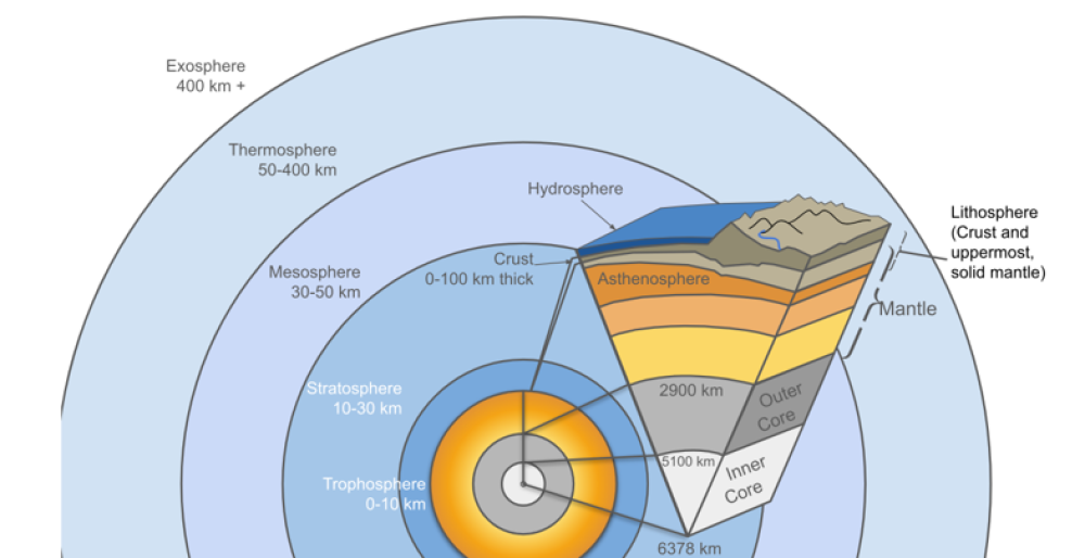
Geoscience is the term used for the combined study of the Earth and its layers. These layers can be described using two different systems because geoscientists study the planet in different ways. One system is based on mechanical properties (how materials behave under stress), and the other is based on chemical composition (what the materials are made of). Both are correct and describe the same planet from different perspectives.
The mechanical (physical) layering includes the lithosphere, asthenosphere, and mesosphere. The lithosphere is the strong, rigid outer layer of Earth, extending to about 100 km deep. It includes the crust and the uppermost mantle and forms the tectonic plates involved in plate tectonics. Beneath it lies the asthenosphere, a weaker, more easily deformed layer that extends from about 100 km to 660 km depth. The asthenosphere is not a liquid. It behaves more like a solid that can slowly flow, allowing tectonic plates to move. Below this is the mesosphere, a stronger layer of the mantle.
The chemical layering divides Earth into the crust, mantle, and core based on composition. The crust is a thin, chemically distinct surface layer made of lighter elements such as silicon, oxygen, aluminium, calcium, sodium, and potassium. It occurs as oceanic crust (about 5–10 km thick) and continental crust (around 33 km thick on average). Beneath the crust is the mantle, which is richer in iron and magnesium and contains minerals such as olivine and pyroxene. The mantle extends to about 2900 km depth.
These two systems overlap. The crust forms the upper part of the lithosphere, while the mantle makes up the lower part of the lithosphere, the entire asthenosphere, and the mesosphere. This overlap explains why different names can be used for the same depth inside the Earth.
Below the mantle lies the core, divided into the outer core (liquid) and inner core (solid or semi-solid). These boundaries represent both mechanical and compositional changes, from solid rock to liquid metal, and then to a more solid inner core.
Using both naming systems helps students understand not just what Earth is made of, but also how its layers behave, which is essential for explaining plate tectonics, earthquakes, and Earth’s internal processes.
The Inquire phase allows students to cycle progressively and with increasing complexity through the key science ideas related to the core concepts. Each Inquire cycle is divided into three teaching and learning routines that allow students to systematically build their knowledge and skills in science and incorporate this into their current understanding of the world.
When designing a teaching sequence, it is important to consider the knowledge and skills that students will need in the final Act phase. Consider what the students already know and identify the steps that need to be taken to reach the level required. How could you facilitate students’ understanding at each step? What investigations could be designed to build the skills at each step?
Read more about using the LIA FrameworkThe Investigate routine provides students with an opportunity to explore the key ideas of science, to plan and conduct an investigation, and to gather and record data. The investigations are designed to systematically develop content knowledge and skills through increasingly complex processes of structured inquiry, guided inquiry and open inquiry approaches. Students are encouraged to process data to identify trends and patterns and link them to the real-world context of the teaching sequence.
When designing a teaching sequence, consider the diagnostic assessment (Launch phase) that identified the alternative conceptions that students held. Are there activities that challenge these ideas and provide openings for discussion? What content knowledge and skills do students need to be able to complete the final (Act phase) task? How could you systematically build these through the investigation routines? Are there opportunities to build students’ understanding and skills in the science inquiry processes through the successive investigations?
Read more about using the LIA FrameworkDeveloping theories
Pose the question: How did scientists develop tectonic plate theory?
Discuss how scientists collaborate and work together to build on each other’s ideas and research.
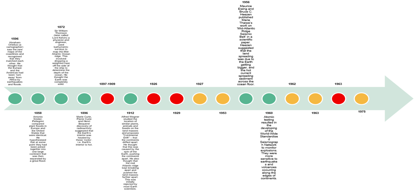
(Slide 18) Provide students with a copy of Cracking the code of moving plates Resource sheet. Discuss the key events embedded on the current timeline, including how the continents were once joined into large land masses.
Explain how there are key elements missing on the timeline:
- Orange events relate to the study of how tectonic plates move.
- Red events relate to the development of the structure of the Earth, including the mantle and core.
Allocate each group of students to cut out a set of timeline events (either orange or red events). Invite students to predict the order in which the historical events occurred that led to the development of the tectonic plate theory. These events should then be placed in the appropriate place in the timeline.
The Inquire phase allows students to cycle progressively and with increasing complexity through the key science ideas related to the core concepts. Each Inquire cycle is divided into three teaching and learning routines that allow students to systematically build their knowledge and skills in science and incorporate this into their current understanding of the world.
When designing a teaching sequence, it is important to consider the knowledge and skills that students will need in the final Act phase. Consider what the students already know and identify the steps that need to be taken to reach the level required. How could you facilitate students’ understanding at each step? What investigations could be designed to build the skills at each step?
Read more about using the LIA FrameworkFollowing an investigation, the Integrate routine provides time and space for data to be evaluated and insights to be synthesized. It reveals new insights, consolidates and refines representations, generalises context and broadens students’ perspectives. It allows student thinking to become visible and opens formative feedback opportunities. It may also lead to further questions being asked, allowing the Inquire phase to start again.
When designing a teaching sequence, consider the diagnostic assessment that was undertaken during the Launch phase. Consider if alternative conceptions could be used as a jumping off point to discussions. How could students represent their learning in a way that would support formative feedback opportunities? Could small summative assessment occur at different stages in the teaching sequence?
Read more about using the LIA FrameworkStanding on the shoulders of giants
(Slide 18 animation) Encourage students to compare the order of their timelines and to discuss how they made their decision. This models how scientists discuss new findings and make decisions based on evidence.
✎ STUDENT NOTES: Paste the completed timeline in the notebook.
(Slide 19) Discuss how the timeline can make scientific discoveries seem linear. While many scientists often build on the ideas of others, some of these events occur simultaneously. Some scientists can also have different opinions and need different levels of evidence before they agree.
- Do you think scientists always know the “next step” in a discovery? Why or why not?
- What does it mean when scientists “build on the ideas of others”?
- Who should get credit for an idea or theory? (Should there be any consequences for Ezing and Heezen for publishing Marie Tharp’s theory?)
- How can one scientist’s work help another scientist fill in a missing gap?
- Why might two scientists look at the same evidence but reach different conclusions?
- How can scientists’ backgrounds, experiences, or fields affect their opinions?
- Is disagreement a bad thing in science? Why or why not?
- Why might one scientist need more evidence than another before agreeing with an idea?
- How does new evidence sometimes change what scientists think?
(Slide 20) Read the quote by Sir Mark Oliphant at the 1981 formal opening of the Australian Academy of Science’s Expanding Earth symposium.
I must admit that I am a rebel, attracted by the boldly unorthodox, and that I have a sneaking wish that the pundits of the present-day accepted cosmology be proven at least partially wrong. I remember in the 1920s, as a student in Adelaide, hearing a debate between Sir Douglas Mawson, Professor of Geology, and Wood-Jones, the Professor of Anatomy, concerning Wegener’s ideas of continental drift. Wood-Jones wanted it to be true, for it helped explain the distribution of animals, plants, and their fossil remains. Mawson, the celebrated geological expert, thought it an absurd idea that rigid rocks could flow in that strange manner.
Carey, S. Warren & Australian Academy of Science & Geological Society of Australia & University of Tasmania. Department of Geology. (1981). The Expanding earth, a symposium: Earth Resources Foundation, University of Sydney, February 10-14, 1981. Hobart: University of Tasmania
This symposium was examining why the tectonic plates moved. At the time, scientists thought that was due to the Earth expanding and becoming larger.
(Slide 21) Ask students to compare the two claims provided by scientists (one from 1981 and one from 2011).
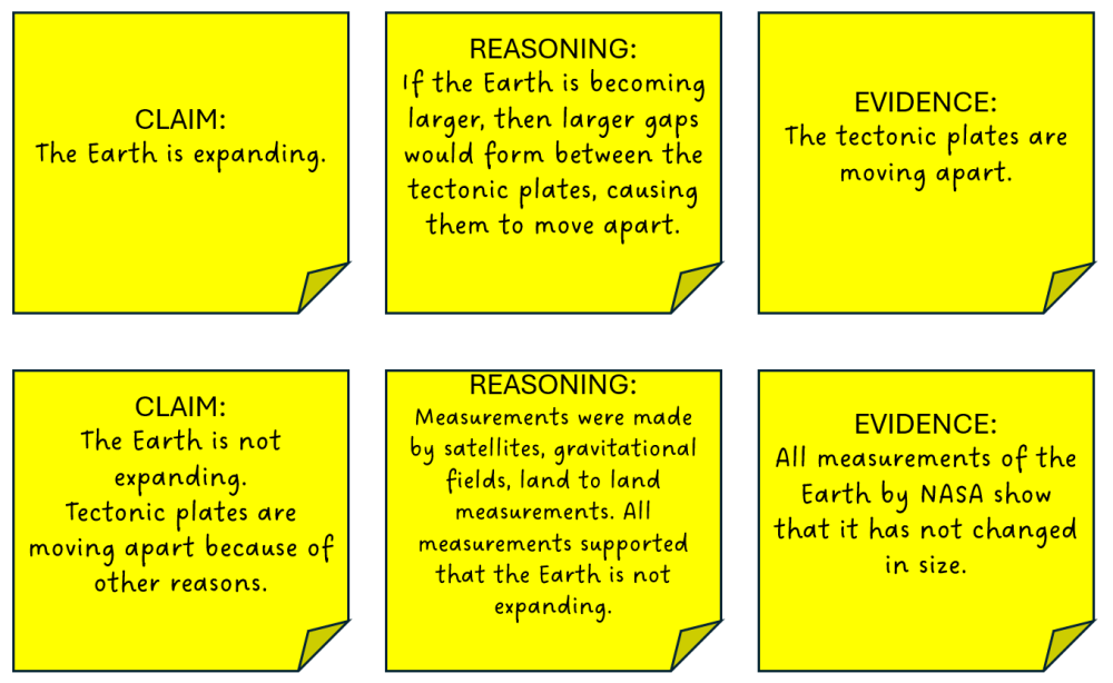
Discuss the importance of testing the link between claims, evidence, and reasoning.
The statement in the first claim may correctly describe an observation or pattern in the evidence. For example, the evidence might show that land masses seem to be moving apart. That observation itself may be accurate. However, simply observing that something is moving or spreading does not automatically support that the Earth is expanding.
The first claim is an attempt to explain the evidence. In science, this type of explanation is called a hypothesis: a possible explanation that can be tested. A hypothesis is not the same as proof. It is one way of making sense of the available evidence, but there may be other explanations that fit the same evidence equally well or better.
In this case, even if the evidence shows separation or movement, that alone does not support that the Earth is expanding. Additional evidence would be needed to specifically support expansion over other explanations. Helping students see this distinction strengthens their understanding of how scientific reasoning works—that explanations must be supported by strong, specific evidence, not just by observations that seem to fit.
✎ STUDENT NOTES: Write an example of how ideas in science have changed from the expanding Earth theory to the theory of plate tectonics over time.
Explain that the next lesson will examine how and why the tectonic plates move.
Reflect on the lesson
You might invite students to:
- cut out the tectonic plates on the Geoscience Australia tectonic plates jigsaw puzzle and put them together, modelling how the tectonic plates are moving.
- research how Gondwana (southern hemisphere land mass) and Laurasia (northern hemisphere land mass) were once combined to form one land mass called Pangea.
- identify one area of science where scientists are still working to identify key elements of a theory.
- research what a geoscientist does by watching the videos 2026 Dorothy Hill Medal award winner Dr Caroline Eakin, or A chat with a geoscientist - Everyday jobs.